Saturday, May 26, 2012

5/25/2012 LaCrosse, KS HaboobNado

Friday contained feelings of disappointment and amazement.  Highlights included a few brief dusty tornadoes just northeast of LaCrosse, KS, including a large dusty haboob-like rear flank occlusion.  The local environment was primed for tornadic supercells, characterized by a northward lifting warm front with backed easterly flow, adequate deep-layer wind shear, plenty 'o moisture, and steep lapse rates contributing to modest instability.  The small limiting factor were the dewpoint depressions, contributing to less than ideal LCLs/LFCs.  Thus, parcels were not "convecting" in the lowest portion of the atmosphere and taking advantage of the excellent low-level directional shear.  As the boundary layer began to cool around sunset, supercells near LaCrosse and Hays began became more tornadic with a 46 minute tornado occurring near LaCrosse.  Unfortunately for us, we stuck with the first storm and just could not understand why it could not get its act together despite the favorable ingredients in place.  We followed this storm east of Hays and new convection began to fire further to the southwest on the now stalled warm front.  We gave it a look initially on radar but figured it was best to just stay put and try to take lightning photos as the sun began to set.  Stupidly, I sat out of the car for about 30 minutes enjoying the sky and taking photos and was not watching radar. Hence, I failed to navigate us to the LaCrosse storm as it began to produce a tornadofest.  I was angry with myself at first, but I realized that it is impossible to see every tornado even if one makes a good forecast (our morning target was LaCrosse and we sat there all afternoon; shoot!).  While I had a bad taste in my mouth most of the night, Craig and Tony were absolutely fascinated with the initial supercell to the northeast of LaCrosse.  Honestly, it was great to see them so excited.  Sometimes experience can immune one to the real joy and excitement that is being on the Great Plains observing convection.  The UGA guys reluctantly head back tomorrow, but it has been great having them as company.  As for me, I will give it one more shot in KS/NE tomorrow before heading home for Memorial Day.
Initiation near LaCrosse, KS
 Supercell beginning to organize just northeast of LaCrosse

Brief tornado underneath a rotating wall cloud
 
Dust associated with an occluding RFD
 Holy dust!
 Time to coin the term Haboobnado?
Starting to look more shelfy now...Was hard to tell if this was a gustnado or associated with pendant just to the north
 Closeup of above
 Sunset supercell & lightning near Hays
 Lightning from this storm actually sparked a wildfire!
Explosive afternoon development across KS via visible satellite

5/24/2012 Wilson Lake State Park

Tony, Craig (UGA graduate students), and I decided to call off Thursday's chasing possibilities in southeast KS due to a strong cap and instead ventured to Wilson Lake State Park in north central KS to camp.  It was a very picturesque location (especially for KS!) and provided a perfect location to set up for our Friday chasing opportunities near Hays, KS.  We enjoyed a fire and a few beverages before calling it an evening. 

This picture is dedicated to our fiancés Jenna and Caitlin :-)
 Beautiful sunset at Wilson Lake State Park

5/23/2012 COnvection

We targeted a marginal setup for supercells in eastern CO on Wednesday with limited moisture in an upslope regime.  One of the supercells sported some nice structure and treated us with a pretty sky just before dusk.  We stayed in Colby, KS on Wednesday night and made it to our hotel before getting a nice hailstorm.  Check back for a timelapse of this setting in the near future...

 Eastern CO supercell
Interesting sky north of Kit Carson, CO

Sunday, May 20, 2012

5/19/2012 Kingman/Harper, KS Tornadoes

We did it!  CoD Trip 2 had everything on the line Saturday after a quiet week in the severe weather world.  We had been watching Saturday's setup for a few days and knew it would be our only hope to bag a tube before heading back to IL.  We awoke at a nice Fairfield Inn in Hays, KS (first time staying there actually; however, I've stayed in Hays numerous other times) with maps printed and ready to analyze.  John Monteverdi (SFSU professor) chatted with us in the morning and was excited to see our students performing hand analysis of the morning observational data.  You could sense the excitement amongst the students, even though it was admittedly not one of the best tornado setups.  Optimistic would probably be the best way to describe our feeling about the day because we were sure there would be storms due to the forcing for ascent, but moisture was limited and upper-level wind vectors were aligned parallel to the surface initiating boundary.  Given these caveats, we were worried that storms in central KS would interact with one another and congeal into an MCS rather quickly.  In days leading up to Saturday, we talked about targeting the Woodward, OK area due to better shear vector orientations relative to the dryline.  However, we noticed this area beginning to fold over and surge southeast due to a building surface ridge on the lee side of the Rockies related to subsidence behind the advancing vorticity maximum. The boundary instead sagged in more of an east/west fashion leading to similar problems of what we were expecting to happen in central KS.  Instead of heading to western OK for the later show due to a stronger cap, we instead hung out most of the afternoon in Pratt, KS watching visible satellite.  It was decided that a better chase strategy would be to play the tail end of bubbling cumulus just west of our location.  These storms quickly became prolific hail producers, but it was apparent that the strength of the forcing and cap were leading to a non-supercellular convective mode.  What happened next was amazing...  We started noticing several high-based [LCLs were near 3 km] funnels just west of Kingman, KS.  A couple of these funnels eventually turned into tornadoes, but they were not associated with mesocyclones.  Instead, I'm assuming that preexisting vorticity near the surface boundary was being stretched by the rapid vertical acceleration near the surface due to the nearly dry adiabatic lapse rates.  Numerous tornadoes were being reported west of Kingman by late afternoon.  We kept dropping south/east with the storm motions and witnessed a long-lived tornado near Harper, KS.  Looking at radar, this tornado appeared to be more of a hybrid with a clear inflow notch and a supercell-like hook echo appendage.  Either way, this tornado was very pretty and the students were fascinated.  The group on this trip was one of the best I've ever had and it was great to get to know them / learn about their lives.  Ten days that I will not soon forget...
Beautiful sky as storms begin to initiate
 Dust being kicked up from mesoscale boundaries
 W of Kingman, KS
 High-based funnel near Kingman
 Needle tornado near Kingman
 Elephant trunk near Harper, KS
 Harper take two...
 Panny view as storms begin to become "shelfy"
0-3km vorticity generation potential valid at 00z 19 May 2012
Getting creative with the CoD Van.  Kudos to Amy for thinking of this! 
 After creating the legs of the Wicked Witch, we found the TIV and decided to make a funny photo opportunity.  It was quite a hit with the ROTATE folk.

5/17-5/18 2012 Hangin' in CO

Thursday and Friday were also "down" days for severe weather as a pesky low pressure system across the Gulf Coast created offshore flow.  So, we decided to head to the front range to enjoy the scenic view of the Rocky Mountains.  We ate great food and enjoyed some beverages after visiting the Garden of the Gods and catching a Colorado Rockies game on Thursday.  We had a great time in the center field bleachers! We stayed in Denver Thursday night and ventured to Bloomfield, CO on Friday morning to visit the Aviation Research Facility branch of the National Center for Atmospheric Research (NCAR).  This was cool as I have never visited before.  Mike Daniels was gracious enough to let us tour the facility and the aircraft hangar.  All students were able to climb up into the research C-130 cockpit and view all of the instrumentation.  Very cool! We overnighted in Hays, KS to position for expected severe storms on [Saturday] what appeared to be the best setup for severe weather of our ten day trip.

 Our "friend" at the Garden of the Gods
 Garden of the Gods
 Overlooking the GoG toward Pike's Peak
 Cool rock formations at the GoG

 C-130 Aircraft in the Research Aviation Facility Hangar
 Research C-130 Cockpit
 Group shot in front of NSF's Research C-130 Aircraft

5/15-5/16 2012 Palo Duro Canyon / Capulin Volcano

Tuesday and Wednesday were down days for CoD Trip 2 as northerly winds across the Great Plains inhibited any chances of severe weather due to limited moisture.  Instead, we visited Palo Duro State Park on Tuesday and Capulin Volcano National Monument. 

 View atop Capulin Volcano
Panny view of Palo Duro Canyon

Monday, May 14, 2012

5/13/2012 Carlsbad, NM > Fort Stockton, TX Bow Echo

CoD trip 2 started the morning after steak the previous night at Cagle’s in Lubbock, TX.  This was after a long two-day drive from Glen Ellyn, IL (stayed in Overland Park, MO the previous night after eating Jess & Jim’s; Yum!).  What was starting to turn into a steak eating tour rather than a storm chasing tour quickly changed Sunday afternoon.  While the setup was certainly less than ideal featuring marginal instability and surface moisture, it was clear that we would need to drive to Carlsbad, NM to have any chance of seeing a storm worth photographing.  After the WORST Pizza Hut stop ever in Hobbs, NM, we drifted southwest to Carlsbad and ended up chatting with Tim Marshall et al. participating in the ROTATE project.  We then drifted south of Carlsbad to throw some rocks and view the beautiful countryside.  Storms were forming to our N, but nothing was severe warned and the visible satellite reeked of grunge leftover from the convection earlier in the morning.  Since we are a “storm-chasing” group (i.e., not specifically tornado chasing), we drifted back N to intercept storms beginning to congeal into an MCS.  After finding a good hill to pull off on, we were treated with a pretty shelf cloud and some good CG lightning.  We stayed ahead of newly formed bow echo now raging SE toward Fort Stockton, TX.  This bow was an amazing experience with a borderline duststorm raging along the cold pool boundary.  We beat the bow to Fort Stockton by about 10 miles before the apex of the bow raged through producing severe wind and nickel size hail.  Overall, it was a fun day considering the parameters in play.  We capped of the night with an all-participatory group party and storm talk session.
 Initial shelf near Carlsbad, NM
 Mammatus pockets near Carlsbad, NM
 Shelf take two...
Night view of the shelf approaching Ft. Stockton, TX
Getting creative with a flashlight! (7/28 is the "big" day)

Thursday, May 3, 2012

5/2/2012 Fullerton, NE Supercell

Wednesday featured a MDT risk for severe storms across eastern portions of NE and western portions of IA.  While good surface moisture and instability were in place, the lack of a large scale focus for convection led to limited coverage of convection across the risk area along and ahead of a mesoscale boundary in eastern NE.  After driving most of the morning and eying visible satellite we (pops and I) latched on to a supercell near Fullerton, NE.  This storm was initially just a high-based hailer (forming back in the steeper lapse rates).  However, after a split, the right-moving portion of the storm started to look much better and was now featuring a persistent wall cloud and broad rotation.  It was pretty clear to me that this storm was *not* going to produce a tornado, as no clear slot was evident (although, the local yokel who pulled up next to us was sure it was going to...).   We stayed ahead of this supercell all the way to Columbus, NE enjoying occasional lowerings and remarkable lightning (none of which would cooperate with my photography!) before calling it a chase.  We ended up in a cheap room in the downtown OMA Doubletree via my priceline skills :-)

 Nice lookin' convection to our S near Hastings, NE
 Interesting lowering just W of Columbus, NE
 Scud-sucking rotation just SW of Fullerton, NE
Broad rotation SW of Fullerton, NE. Video here.

Wednesday, April 18, 2012

4/14/2012 Dacoma / Cherokee, OK Tornadoes

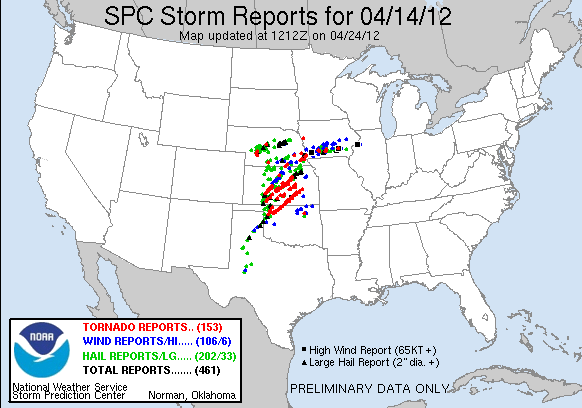
After Friday's disappointment,  we awoke in OKC with sights on central KS for a highly anticipated "High Risk" of severe thunderstorms (Saturday was the main reason we decided to take the trip from AHN).  Most of the morning and afternoon turned out to be interesting from a meteorological standpoint.  Elevated convection was forming early in western/central KS and moving northeast across the central part of the state.  This convection and attendant cloud cover helped to minimize surface heating throughout a majority of the late morning/afternoon.  After heading west out of McPherson, KS we targeted new convection (slowly becoming surface based via RADAR appearance) just to the southwest of Dodge City, KS.  Due to a dead-end road (we got delormed!), we were forced sit and wait, squinting as hard as we could, at a reported wedge tornado to our southwest (see Tornado location (1) on chase log map).  As the wedge was approaching us, we were absolutely convinced that what we were watching to our west (albeit *very* poor contrast; couldn't even get a decent picture) was going to be the beginning of a huge day.  Turns out, we were dead wrong.  This tornado would not give us the pleasure of a good view as it lifted before coming within range of us.  Considering it was only ~1:30 PM CST, we weren't too discouraged, as there was plenty 'o daylight left, and ample insolation now occurring just ahead of the dryline in western OK and KS.  We stuck with this storm for a little while before deciding to bail to another storm to the south.  The decision was largely based on two failed attempts at tornadogenesis and the relatively "cool" feeling of the inflow feeding the cell.  We then intercepted a new cell coming out of OK (series of purple dots just north of the KS/OK border) and stuck with it for another two rounds of failed tornadogenesis.  At this time, there were basically 4 mature supercells traversing northern OK/Central KS, and we seemed to be positioned on the best looking cell in terms of RADAR appearance.  However, visually, the storm sucked!  Argh!  By this time, it's about 6:35 PM CST and I was thoroughly convinced that supercells we latched onto were not going to "produce" due to decreased surface lapse rates. I feared we were going home empty handed! We decided to give it one last go at a cell further to the south in Oklahoma that was heading toward Woods County.  This storm looked much better visually and didn't have any other convection to the south to alter the thermodynamics of the inflow parcels.  I started to feel much better as the storm began to show evidence of a nice clear slot, and it wasn't long before we spotted a tornado (see Tornado (2) on chase log).  This cell was one heck of a tornado producer, that went on to produce confirmed tornadoes intermittently all the way on the western side of Wichita, KS!  We observed at least two (maybe three?) tornadoes with this cell before calling it a chase as the darkness settled in (see Tornado (3) and (4) on chase log).  Tornadoes 3 and 4 were also the first time I have seen two tornadoes, or "sisters" as some chasers call them, at once.  What a treat!  We could have easily kept chasing given the isolated nature of the storm, but confirmed large tornadoes and darkness to not bode well together for chasing.  Thus, we may have missed some of the nighttime show, but at least we'll live to chase again :-)  After overnighting in Ponca City, OK, we made the trek back home to AHN.  Overall,  a very memorable chase! 

Meteorologically, I found these storms to be rather interesting and reminiscent of tornadoes described on 3 May 1999.  There were virtually no large hail reports with these supercells after the initiation stage, as well as very few cloud-to-ground lightning strikes. Interesting...

--------------------------------------------------------------------------------------------------------------
Chase log

Left this cell after two failed attempts and relatively "cool" inflow

Finally on our "target" storm
  
Near Dacoma, OK ; Tornado to our WSW (we saw plenty of dust swirls)
 
 New meso and tornado forming to our N...Tree gets picked up!  (click to enlarge)

  
We jogged a little east and north to get a better view of the new tornado
  
 Wow! Looking good now
 A few min later...
 Still looking N
 Nothing like being right in it ;-)  Good thing GPS data was old!
 A new tornado now forming to the northeast.  We've got sisters! 
Rope stage of the initial tornado
We jogged east and north one last time to take a look at the new tornado to our northeast, but light was quickly diminishing (contrast enhanced)

10x video of the chase can be found here.  My equipment sucks and I was too occupied by taking stills, so the video is not great.  Someday, I'll upgrade :-)