Sunday, May 20, 2012

5/19/2012 Kingman/Harper, KS Tornadoes

We did it!  CoD Trip 2 had everything on the line Saturday after a quiet week in the severe weather world.  We had been watching Saturday's setup for a few days and knew it would be our only hope to bag a tube before heading back to IL.  We awoke at a nice Fairfield Inn in Hays, KS (first time staying there actually; however, I've stayed in Hays numerous other times) with maps printed and ready to analyze.  John Monteverdi (SFSU professor) chatted with us in the morning and was excited to see our students performing hand analysis of the morning observational data.  You could sense the excitement amongst the students, even though it was admittedly not one of the best tornado setups.  Optimistic would probably be the best way to describe our feeling about the day because we were sure there would be storms due to the forcing for ascent, but moisture was limited and upper-level wind vectors were aligned parallel to the surface initiating boundary.  Given these caveats, we were worried that storms in central KS would interact with one another and congeal into an MCS rather quickly.  In days leading up to Saturday, we talked about targeting the Woodward, OK area due to better shear vector orientations relative to the dryline.  However, we noticed this area beginning to fold over and surge southeast due to a building surface ridge on the lee side of the Rockies related to subsidence behind the advancing vorticity maximum. The boundary instead sagged in more of an east/west fashion leading to similar problems of what we were expecting to happen in central KS.  Instead of heading to western OK for the later show due to a stronger cap, we instead hung out most of the afternoon in Pratt, KS watching visible satellite.  It was decided that a better chase strategy would be to play the tail end of bubbling cumulus just west of our location.  These storms quickly became prolific hail producers, but it was apparent that the strength of the forcing and cap were leading to a non-supercellular convective mode.  What happened next was amazing...  We started noticing several high-based [LCLs were near 3 km] funnels just west of Kingman, KS.  A couple of these funnels eventually turned into tornadoes, but they were not associated with mesocyclones.  Instead, I'm assuming that preexisting vorticity near the surface boundary was being stretched by the rapid vertical acceleration near the surface due to the nearly dry adiabatic lapse rates.  Numerous tornadoes were being reported west of Kingman by late afternoon.  We kept dropping south/east with the storm motions and witnessed a long-lived tornado near Harper, KS.  Looking at radar, this tornado appeared to be more of a hybrid with a clear inflow notch and a supercell-like hook echo appendage.  Either way, this tornado was very pretty and the students were fascinated.  The group on this trip was one of the best I've ever had and it was great to get to know them / learn about their lives.  Ten days that I will not soon forget...
Beautiful sky as storms begin to initiate
 Dust being kicked up from mesoscale boundaries
 W of Kingman, KS
 High-based funnel near Kingman
 Needle tornado near Kingman
 Elephant trunk near Harper, KS
 Harper take two...
 Panny view as storms begin to become "shelfy"
0-3km vorticity generation potential valid at 00z 19 May 2012
Getting creative with the CoD Van.  Kudos to Amy for thinking of this! 
 After creating the legs of the Wicked Witch, we found the TIV and decided to make a funny photo opportunity.  It was quite a hit with the ROTATE folk.

5/17-5/18 2012 Hangin' in CO

Thursday and Friday were also "down" days for severe weather as a pesky low pressure system across the Gulf Coast created offshore flow.  So, we decided to head to the front range to enjoy the scenic view of the Rocky Mountains.  We ate great food and enjoyed some beverages after visiting the Garden of the Gods and catching a Colorado Rockies game on Thursday.  We had a great time in the center field bleachers! We stayed in Denver Thursday night and ventured to Bloomfield, CO on Friday morning to visit the Aviation Research Facility branch of the National Center for Atmospheric Research (NCAR).  This was cool as I have never visited before.  Mike Daniels was gracious enough to let us tour the facility and the aircraft hangar.  All students were able to climb up into the research C-130 cockpit and view all of the instrumentation.  Very cool! We overnighted in Hays, KS to position for expected severe storms on [Saturday] what appeared to be the best setup for severe weather of our ten day trip.

 Our "friend" at the Garden of the Gods
 Garden of the Gods
 Overlooking the GoG toward Pike's Peak
 Cool rock formations at the GoG

 C-130 Aircraft in the Research Aviation Facility Hangar
 Research C-130 Cockpit
 Group shot in front of NSF's Research C-130 Aircraft

5/15-5/16 2012 Palo Duro Canyon / Capulin Volcano

Tuesday and Wednesday were down days for CoD Trip 2 as northerly winds across the Great Plains inhibited any chances of severe weather due to limited moisture.  Instead, we visited Palo Duro State Park on Tuesday and Capulin Volcano National Monument

 View atop Capulin Volcano
Panny view of Palo Duro Canyon

Monday, May 14, 2012

5/13/2012 Carlsbad, NM > Fort Stockton, TX Bow Echo

CoD trip 2 started the morning after steak the previous night at Cagle’s in Lubbock, TX.  This was after a long two-day drive from Glen Ellyn, IL (stayed in Overland Park, MO the previous night after eating Jess & Jim’s; Yum!).  What was starting to turn into a steak eating tour rather than a storm chasing tour quickly changed Sunday afternoon.  While the setup was certainly less than ideal featuring marginal instability and surface moisture, it was clear that we would need to drive to Carlsbad, NM to have any chance of seeing a storm worth photographing.  After the WORST Pizza Hut stop ever in Hobbs, NM, we drifted southwest to Carlsbad and ended up chatting with Tim Marshall et al. participating in the ROTATE project.  We then drifted south of Carlsbad to throw some rocks and view the beautiful countryside.  Storms were forming to our N, but nothing was severe warned and the visible satellite reeked of grunge leftover from the convection earlier in the morning.  Since we are a “storm-chasing” group (i.e., not specifically tornado chasing), we drifted back N to intercept storms beginning to congeal into an MCS.  After finding a good hill to pull off on, we were treated with a pretty shelf cloud and some good CG lightning.  We stayed ahead of newly formed bow echo now raging SE toward Fort Stockton, TX.  This bow was an amazing experience with a borderline duststorm raging along the cold pool boundary.  We beat the bow to Fort Stockton by about 10 miles before the apex of the bow raged through producing severe wind and nickel size hail.  Overall, it was a fun day considering the parameters in play.  We capped of the night with an all-participatory group party and storm talk session.
 Initial shelf near Carlsbad, NM
 Mammatus pockets near Carlsbad, NM
 Shelf take two...
Night view of the shelf approaching Ft. Stockton, TX
Getting creative with a flashlight! (7/28 is the "big" day)

Thursday, May 3, 2012

5/2/2012 Fullerton, NE Supercell

Wednesday featured a MDT risk for severe storms across eastern portions of NE and western portions of IA.  While good surface moisture and instability were in place, the lack of a large scale focus for convection led to limited coverage of convection across the risk area along and ahead of a mesoscale boundary in eastern NE.  After driving most of the morning and eying visible satellite we (pops and I) latched on to a supercell near Fullerton, NE.  This storm was initially just a high-based hailer (forming back in the steeper lapse rates).  However, after a split, the right-moving portion of the storm started to look much better and was now featuring a persistent wall cloud and broad rotation.  It was pretty clear to me that this storm was *not* going to produce a tornado, as no clear slot was evident (although, the local yokel who pulled up next to us was sure it was going to...).   We stayed ahead of this supercell all the way to Columbus, NE enjoying occasional lowerings and remarkable lightning (none of which would cooperate with my photography!) before calling it a chase.  We ended up in a cheap room in the downtown OMA Doubletree via my priceline skills :-)

 Nice lookin' convection to our S near Hastings, NE
 Interesting lowering just W of Columbus, NE
 Scud-sucking rotation just SW of Fullerton, NE
Broad rotation SW of Fullerton, NE. Video here.

Wednesday, April 18, 2012

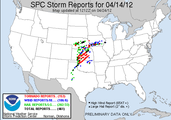
4/14/2012 Dacoma / Cherokee, OK Tornadoes

After Friday's disappointment,  we awoke in OKC with sights on central KS for a highly anticipated "High Risk" of severe thunderstorms (Saturday was the main reason we decided to take the trip from AHN).  Most of the morning and afternoon turned out to be interesting from a meteorological standpoint.  Elevated convection was forming early in western/central KS and moving northeast across the central part of the state.  This convection and attendant cloud cover helped to minimize surface heating throughout a majority of the late morning/afternoon.  After heading west out of McPherson, KS we targeted new convection (slowly becoming surface based via RADAR appearance) just to the southwest of Dodge City, KS.  Due to a dead-end road (we got delormed!), we were forced sit and wait, squinting as hard as we could, at a reported wedge tornado to our southwest (see Tornado location (1) on chase log map).  As the wedge was approaching us, we were absolutely convinced that what we were watching to our west (albeit *very* poor contrast; couldn't even get a decent picture) was going to be the beginning of a huge day.  Turns out, we were dead wrong.  This tornado would not give us the pleasure of a good view as it lifted before coming within range of us.  Considering it was only ~1:30 PM CST, we weren't too discouraged, as there was plenty 'o daylight left, and ample insolation now occurring just ahead of the dryline in western OK and KS.  We stuck with this storm for a little while before deciding to bail to another storm to the south.  The decision was largely based on two failed attempts at tornadogenesis and the relatively "cool" feeling of the inflow feeding the cell.  We then intercepted a new cell coming out of OK (series of purple dots just north of the KS/OK border) and stuck with it for another two rounds of failed tornadogenesis.  At this time, there were basically 4 mature supercells traversing northern OK/Central KS, and we seemed to be positioned on the best looking cell in terms of RADAR appearance.  However, visually, the storm sucked!  Argh!  By this time, it's about 6:35 PM CST and I was thoroughly convinced that supercells we latched onto were not going to "produce" due to decreased surface lapse rates. I feared we were going home empty handed! We decided to give it one last go at a cell further to the south in Oklahoma that was heading toward Woods County.  This storm looked much better visually and didn't have any other convection to the south to alter the thermodynamics of the inflow parcels.  I started to feel much better as the storm began to show evidence of a nice clear slot, and it wasn't long before we spotted a tornado (see Tornado (2) on chase log).  This cell was one heck of a tornado producer, that went on to produce confirmed tornadoes intermittently all the way on the western side of Wichita, KS!  We observed at least two (maybe three?) tornadoes with this cell before calling it a chase as the darkness settled in (see Tornado (3) and (4) on chase log).  Tornadoes 3 and 4 were also the first time I have seen two tornadoes, or "sisters" as some chasers call them, at once.  What a treat!  We could have easily kept chasing given the isolated nature of the storm, but confirmed large tornadoes and darkness to not bode well together for chasing.  Thus, we may have missed some of the nighttime show, but at least we'll live to chase again :-)  After overnighting in Ponca City, OK, we made the trek back home to AHN.  Overall,  a very memorable chase! 

Meteorologically, I found these storms to be rather interesting and reminiscent of tornadoes described on 3 May 1999.  There were virtually no large hail reports with these supercells after the initiation stage, as well as very few cloud-to-ground lightning strikes. Interesting...

--------------------------------------------------------------------------------------------------------------
Chase log

Left this cell after two failed attempts and relatively "cool" inflow

Finally on our "target" storm
  
Near Dacoma, OK ; Tornado to our WSW (we saw plenty of dust swirls)
 
 New meso and tornado forming to our N...Tree gets picked up!  (click to enlarge)

  
We jogged a little east and north to get a better view of the new tornado
  
 Wow! Looking good now
 A few min later...
 Still looking N
 Nothing like being right in it ;-)  Good thing GPS data was old!
 A new tornado now forming to the northeast.  We've got sisters! 
Rope stage of the initial tornado
We jogged east and north one last time to take a look at the new tornado to our northeast, but light was quickly diminishing (contrast enhanced)

10x video of the chase can be found here.  My equipment sucks and I was too occupied by taking stills, so the video is not great.  Someday, I'll upgrade :-)

Tuesday, April 17, 2012

4/13/2012 HP Zits

Friday featured a concentrated, but interesting "day-before-the-day" setup for severe convection along a retreating dryline in western Oklahoma. Alan, Chuck, Matt, and I pulled the trigger on chasing the weekend convection and decided to leave Thursday evening, making it to Conway, AR, before overnighting. The chase turned out to be a little disappointing, with cells appearing very HP'ish both visually and on RADAR. Surface temperatures also seemed a little "cool," which likely inhibited steep lapse rates in the boundary layer. We latched on to a few HP supercells, one of them being near Blair, OK. There was a tornado reported with this storm after we left it (I know of a few chasers that claim to have video), but WFO OUN still has not issued any tornado LSR's associated with this cell. Below are some pictures (including some great anvil zits; some of the better I've witnessed) of the Blair storm as it edged eastward.
Outflow dominant HP supercell
Great CC lightning with plenty of anvil zits

Monday, April 9, 2012

Student Fees @ UGA

I normally refrain from posting non-weather/political commentary on this blog, but recent events have forced me to crunch some numbers. Numbers specifically related to student fee payments at the University of Georgia.

My tenure at UGA has consisted only of being a Ph.D. student (synonymous with graduate student for purposes of this post), so I am limited to this perspective. However, during my two years here I have witnessed student fees increase by 48.4%! The average graduate student (without a fee waiver) at UGA will pay roughly $844 to enroll in classes just for this year's summer session! (Table 1)

Table 1: 2006-2012 Graduate Student Fees at UGA by Category (click to enlarge)

A majority of this increase has come in the form of an "Institutional Fee" (Figure 1). In fact, the 2012 annual cost of the institutional fee alone is now roughly equal total annual student fees charged in 2007. Somewhere buried in UGA website, I was able to muster that the "Institutional Fee" was implemented in FY 2010 to "*help maintain the academic quality that you demand*". Ha! To me, this is also known as, "We are trying to not make cuts to positions across campus."

Figure 1: FA/SP Semester Changes in Fees (click to enlarge)

Looking at the annual total, one can easily see the increasing burden being put on graduate students at UGA (Figure 2). The average UGA graduate student now pays roughly $3,034 in annual student fees, up from $1,395 just five years ago. This equates to a 117.5% increase in just five years!

Figure 2: Annual UGA Graduate Student Fees FY 2007 - Present (click to enlarge)

IMO, this all stems from a much bigger problem in 'Merica today. It is quite easy to see the disinvestment in higher education at the state (and I would argue Federal too!) level. State cuts school budget; school doesn't want to raise tuition to look "affordable"; student fees are raised to account for this lack of investment. This puts all of the burden on the student!

When will it end? I cannot say for sure, but it does appear to me to be eerily similar to the collapse of the housing market. Skyrocketing costs of education and the pressure of attending college are forcing students to enter into loans that have absurd interest rates after graduation. If they cannot find a job (not the easiest thing to do in this current economic climate!), they will likely end up defaulting on their loan. Sound familiar?

I'm glad my terminal degree is on the horizon...

Saturday, March 3, 2012

2 March 2012 Radar Animation

BREF Tilt 1 / Surface Observations / NWS Tornado Warnings

Friday, December 16, 2011

New Diagnostic Weather Data Webpage

Friends interested in meteorology:

It is often taught that meteorologists should first diagnose what is currently occurring in their forecast location, why it is occurring, and how it will impact a future forecast. However, it has been my experience (there are likely differing opinions here) that many forecasters today love to skip right to the forecasting step, without taking the time to make a proper diagnosis of what is currently occurring in the atmosphere. They have become so dependent on products (e.g., model QPF) without a proper understanding of how or why the model is generating precipitation. Unfortunately, this model "cancer" has left these forecasters with nothing more than a crutch on which to blame their failed forecast. Don't misunderstand me, computer models are certainly the best tool for forecasting as they can solve fundamental atmospheric equations far more efficiently than any human. However...

What good is any forecast without a proper diagnosis?

Would you purchase a block of shares in a company based solely on a projected stock price? I sure hope not!

Would a good doctor give you medications to treat a disease without some sort of diagnosis?

As you know, there are plenty of graphs and charts on they web that provide diagnostic information for meteorologists (e.g., surface maps, sounding plots, cross section analysis; I have over 10 pages bookmarked!) However, if you are like me, you are often left saying, "What about other fields," or perhaps more commonly, "there has to be a better way to present such data." Personally, I find many plots hard to read, rather cluttered, or just plain visually unappealing. IMO this is partly due to the fact that many people and organizations that present such data care more about ease of production and content rather than the presentation of that data to the user. Surely content is important, but it is ultimately how the user will interpret that data that makes all the difference in the forecast process! Of course, the main challenge here is that personal preference differs amongst forecasters. Some forecasters like a particular color scale, others do not. Some are colorblind. Some cannot interpret a map that is too cluttered. This is similar to one of the main challenges facing graphics design artists!

Last spring I set out on a mission to create appealing maps and provide unique diagnostic fields that I have trouble finding elsewhere on the web. You'll see that many of the maps I provide are nothing more than "pretty colors" to the untrained eye. However, I've tried to make the graphics as visually appealing as possible without sacrificing content (maybe they don't appeal to you; that's fine too!). I'll be the first to admit that the use of a map with a pretty color scale and neat graphics means little if the user fails to interpret it correctly. Unfortunately, this is not a skill you can develop overnight (just ask a veteran forecaster). My favorite reminder of this comes from Bosart (2002):
If you don't like a particular map or would like an alternate color scale, e-mail me and I'll see what I can do. That is one of the [only?] benefits of working on such a product by yourself).

Okay, now for the goodies:

The URL for the new page can be found at http://vgensini.myweb.uga.edu/wx

Fields currently offered:

Observational (Based on Sounding or Surface Stations)
  • 300, 500, 700, 850 mb isosurface
  • 0-500m MLCAPE
  • Precipitable Water
  • 12h 500mb Height Change
  • Sounding profiles for selected upper-air stations
  • Surface stations
  • 2m θe
  • Surface moisture flux divergence
  • Cross Sections: KGGW - KLCH ; KLBF - KWAL
  • Isentropic analysis at various θ levels
RUC Initialization Fields (00h Forecast; Interpolated to a 211 AWIPS grid ~80km)
  • 300, 500, 700, 850 mb isosurface
  • 300 mb Divergence
  • 500 mb Absolute Vorticity
  • 500 mb Absolute Vorticity Advection
  • 500 mb Absolute Vorticity and Water Vapor (my personal favorite)
  • 700 mb Absolute Vorticity Advection
  • 700 mb Frontogenesis
  • 500-700 mb Layer Average Q-Vector Divergence
  • 500-850 mb Wind Crossovers
  • 850 mb Temperature & Moisture Advection
  • Trenberth Forcing Term
For more information on the fields, visit the metadata link.

Perhaps my favorite aspect is the ability to select the "ani" versions of these products to easily mouse over previous hours to provide an animation of the trends in the field. This trend analysis is key in a proper diagnosis.

I'm still struggling a bit with exactly how I want to display the hyperlinks to the products. I'm not a big fan of the current frames approach I am using, but the UGA student web-server is currently limited (no access to php). Perhaps this format change in the future when this page migrates to a new web hosting solution.

Enjoy!