Wednesday, June 22, 2011

6/20/2011 Almena, KS & Stamford, NE Tornadoes

6/20 featured an interesting "cold core-ish" type set up in the central Great Plains with another SPC moderate risk for severe weather. Walker and I enjoyed breakfast at our overnight hotel (Ramada Inn) in Kearney, NE before deciding to venture southwest to intercept some elevated convection moving our way out of northwest KS. On our drive toward this cell, we stopped for lunch at a local diner (Frosty Mug) in Franklin, NE, and closely watched the evolution of this cell. After lunch, we decided to go after this cell after it appeared to quickly become surface based. It was a little tough to get "suckered" south into KS, as the 1630 Z SPC tornado risk (and most of the high-resolution model guidance) suggested that the environment along and northwest of I-80 in central NE would become quite favorable for tornadoes during the late afternoon and evening. Nevertheless, we continued to chug towards this cell. It turned out to be a good decision, as the now surface based supercell ended up producing several tornadoes, including a beautiful half-dust ingested tornado south of Almena, KS. I was in charge of taking video while Walker took stills (days like these can be very stressful alone, and it was great to have another person in the car). Thus, you'll have to wait for Walker's post for the (IMO great) still photos. Until then, enjoy the video and suboptimal pictures that I have uploaded. I apologize for the jerky video in some parts as the wind was pretty intense. We followed this cell north ending up near Stamford, NE, and along the way we witnessed several tornadoes that quickly became rain-wrapped. We eventually broke off with this storm (it was our original plan to do so), to catch up with convection firing further E along and north of I-80. I suspect that this convection didn't have the same storm-relative directional shear that was present with our initial storm (inflow winds were northeasterly into Almena/Stamford storm, while storms to the east were in an environment characterized by southeasterly surface flow) and thus failed to "produce." One of the more interesting features throughout the day were the numerous small (what appeared to be) forward flank mesovorticies. These vorticies exhibited tornadic rotation and often produced swirls of dust at the surface. Certainly a day that I will never forget. We ended the day in Lincoln, NE feeling like champions. Kudos to Walker for helping navigate a rather poor road network along the KS/NE border...look for his post in the offing.
Rain-wrapped barrel tornado (end of Hill City, KS wedge that Mike U. witnessed)
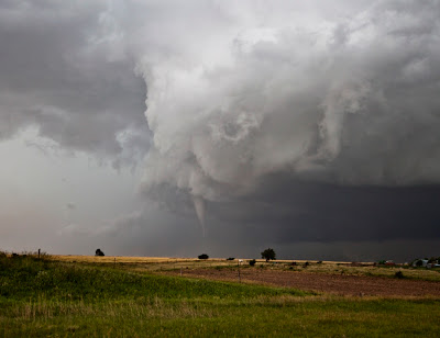
New emerging meso and attendant tornado
Video capture of needle-cone tornado S of Almena, KS (approx 2:25 PM CDT)
Video of the entire event here
Watch out for dust! (approx 2:30 PM CDT)
Dust filled meso begins to occlude as its crossing near the highway 36/60 junction
And another...
Tornado roping out near Stamford, NE
A beautiful fibrous sky near Stamford, NE

6/19/2011 Highway 34 Supercells

6/19 marked the beginning of a mini chase trip to the Great Plains as a slow-moving late June high-amplitude west coast trough led to a moderate risk of severe weather from the Storm Prediction Center. Walker Ashley and I departed northern Illinois early on the 19th with our eyes set on on far western NE or even eastern CO as lee cyclogenesis was forecast to advect sufficient moisture for supercells into the region under sufficient bulk shear corresponding to a tightening height gradient. After bailing on some initial crapvection in eastern CO, we latched on to the westernmost supercell forming near Haigler, NE. This storm looked great initially, but quickly became pinched off of high theta-e air from the cell to its immediate east. Realizing this, we darted east towards the dominant cell and caught up with it in the Stratton area where we observed a brief ground dust swirl that was reported as a weak tornado in the storm report log. We stayed ahead of this monster all the way to the Cambridge/Arapahoe, NE area, all the while exhibiting a beautiful upside-down wedding cake appearance. We drove north to overnight in Kearney, NE, where it turned out to be a pretty stormy evening.

Initial robust supercell development near Haigler, NE
Brief dust swirl near McCook, NE
Click for animation

Wednesday, June 15, 2011

6/15/2011 Moonbow

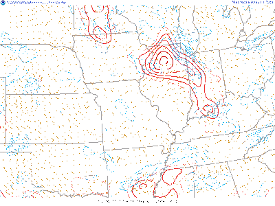
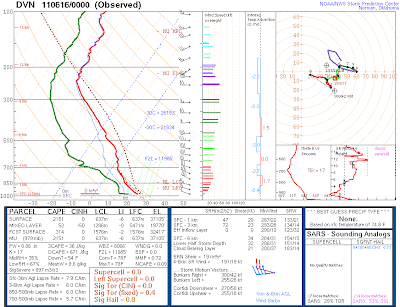
Decaying convection ahead of a small, compact shortwave trough provided a rather unique (and admittedly unexpected) chance for night photography (~10:30 PM) in my backyard. The environment was characterized by relatively robust CAPE in the lowest 3 km, with sufficient shear as noted by the 00z DVN sounding.
Although the rather impressive lightning display decided to quit as soon as I set up my tripod (figures!), I still managed to capture a few shots that I thought were pretty unique. As the small cell was approaching;
Yellow '+' indicates my position

light from a full moon in the low southeastern sky yielded enough light to produce a rainbow! I was shocked at first to see this, let alone find out later that it showed up in a couple of my pictures. The rest of the photo session was characterized by very stable air behind the cell where stars were shining like diamonds.
Moonbow! (hard to believe this was at 10:30 PM)
Dad taking in the view...
Facing south after cell passage

Ani-GIF of the Big Dipper (click to enlarge)

Tuesday, June 7, 2011

6/3-6/4 Down Day & CO Bust

6/3 featured a down day as long-wave ridging was controlling most of the central CONUS. While weak storms did fire in northwest KS (as we anticipated), we opted for a day in the Badlands of South Dakota and ended the day camping in Scottsbluff, NE in preparation for an upslope opportunity in Colorado on 6/4.

Campsite near Scottsbluff, NE national monument.

6/4 was yet another moisture-starved setup in eastern CO. We were hoping for a few landspouts with the very steep low-level lapse rates, but the cap would have none of it. We met up with CoD Trip 3 in a park near Kiowa, CO and watched a few cells quickly form and fizzle out.
Marius (trip 3 CoD) is victim of a frisbee "you threw it, you get it" rule

5/12 - 5/22 CoD Trip 2

From 5/12 - 5/22 I assisted teaching the College of Dupage's experiential learning thunderstorm laboratory course with colleague Paul Sirvatka. Every year there are 5 trips that each take 14 lucky participants into the beautiful, vast emptiness that is the U.S. Great Plains. The trip is open to anyone and differs from most storm chasing tour experiences in that it is relatively cheaper, and allows one to earn college credit! We do our best to allow students to learn the intricacies of severe weather forecasting while enjoying severe storms and awesome local food (typically BBQ!). Below are some pictures of my account on trip 2. Also, a big kudos to Jeff and Jim for safely driving us on our 3500+ mi. journey!
All smiles as we leave CoD!
First stop! Lunch @ Wildwood Smokehouse & Saloon. Near Iowa City, IA. 5/15/2011
Thumbs up for Wildwood!
Paul happy to be back at Jess & Jim's (S side of KS city). 5/15/2011
Nothing left on the table after leaving...yum!
Lunch @ Hog Wild BBQ Pit. 5/16/2011
Dinner @ BJ's in Norman, OK. 5/16/2011
Dinner in Guymon, OK 5/17/2011
Clarke very excited to get some real brisket.
Dinner in Oklahoma City, OK. 5/18/2011
Lunch in Guthrie, OK. 5/20/2011
Dinner in Wichita, KS. 5/20/2011
Trip 2 participants
My attempt at comically describing a high-based supercell
HDR shot of the "storm of the trip." Near Emporia, KS. 5/21/2011
More pictures from this day can be found here.
My my...Is that a clear slot I see?
Tornado moving northeast out of Emporia, KS. 5/21/2011
Video capture of a tornado moving toward Reading, KS. 5/21/2011
Watch video here.
Paul frustrated trying to find an semi-inverted glaciated non-rotating wall cloud. 5/22/2011

Interested in chasing with the College of DuPage? I recommend visiting this link first.

Friday, June 3, 2011

6/2/2011 The Little Cell That Couldn't: Part 2

Thursday featured a rather lengthy drive north to Mobridge, SD with hopes for an isolated supercell near sunset. Trends during the late morning/early afternoon began to suggest that the best convergence was occurring a bit further west across western SD. Knowing that the cap was atomic and nothing was going to materialize till late evening, we sat in a park in Mobridge with CoD trip 3 and talked through potential convective scenarios. The main issue was that our new western target would put us on the west side of the Missouri River with only a couple road options for crossing on our inevitable route back towards the east (this turned out to be trivial as the storms died before crossing...). In short, storms began to fire in our new target in an area of enhanced convergence along a dryline. These storms were, well, disappointing. I think they were struggling with the cap, but like yesterday, a dominant updraft was absent. We followed the multicell mess back to the Mobridge area, and shot a few lightning photos on the way back to our overnight location in Fort Pierre, SD. Tomorrow doesn't look to great, but we may chase in southern Nebraska/nw KS. More than anything, it will be a repositioning day for better storms in CO on Saturday.
Ryan takes in the best view of the day...
HDR attempt at the multicell mess

Thursday, June 2, 2011

6/1/2011 The Little Cell That Couldn't

After staying in Omaha, NE on Wednesday, Thursday exhibited a slight risk of severe storms across our target area of sw NE. While driving to the McCook, NE area, a nice towering cumulus field was beginning to develop on the nose of a rather impressive theta-e axis. We played some frisbee in Barnett Park while watching cumulus batter each other, trying to figure out which "pulse" was going to become the big show. A rather persistent area of moderately strong battering was occurring just to our east near Cambridge, NE, so we headed that way to check things out. The first initial updraft/downdraft was maturing visually and through its radar appearance. I had really hoped that this storm would set the stage for the rest of the day, but that turned out not to be the case. The storm presented a nice updraft base and vault region, with a rugged scud-sucking wall cloud. We were on our own road with nobody in site...definitely a highlight of the day! What occurred for the next several hours was rather frustrating. The storm became very "pulsy" in nature and could not decide on a dominant updraft. We stuck with this Little Cell That Couldn't until it became very laminar and shelfy in nature near the Elm Creek, NE area, then broke it off and headed back northwest to our overnight location in North Platte, NE, where we ran into CoD trip 3 at the local Applebees. Today looks rather interesting, albeit a pretty lengthy drive. We will be departing for central Dakota shortly...

Looking good to start!
Panny view of the laminar appearance